Wednesday, May 30, 2007
S/V Ravens' Dream

Ravens' Dream is a 1976 - 30' Grampian sailing sloop. She is our
second sailboat since moving to British Columbia in 1988. We came
across her one evening in Nanaimo. We were out for a walk along
Stewart Avenue, on our way back to Port Hardy, when we both noticed a
mast with a great "rake" to it. It was love at first sight! We
decided to stay over night, and go back for a better look in the
morning. After a short sail around Newcastle Island, we negotiated a
deal, and now where the owners of two sailboats!
Our sailing lives have varied greatly. Mine had consisted of going
out occasionally as a guest on friends boats on Lake Ontario once in
awhile before moving to B.C., so with that and my mere 18 years of
sailing here, pails in comparison to Jim, who on the other hand has
been sailing since he was 6 years old. He was raised in Foster Care
and ended up with a family who had a son of their own who was
10 years older then Jim. Burt had taught himself how to sail by
rigging canoes with sails in the beginning, then he started building small sailboats himself.
By the time Jim was 6, Burt would take Jim with him and they
would sail around the Islands in Toronto harbour, Then by the time
Jim was 10 to 12 they began sailing across Lake Ontario usually at
night on Fridays. Burt taught Jim how to steer a compass course, and
he would go below and cook supper while Jim sailed the boat. Burt was
working by this time, so they would leave Friday evenings, over to
Niagara-on-the-Lake, and come back on Sunday afternoons. Even years
later when Jim had joined the Navy, and would come home to Toronto on
leave in the summer, they would still sail together.
We lived and worked in Port Hardy at the time we purchased Raven'
Dream (this is the name we gave her when we re-registered her) so we
sailed Queen Charlotte Strait, and then we moved to Comox in 1992 and
to Qualicum Bay in 2002 so we have enjoyed the Georgia Strait area,
Desolation Sound and the Sunshine Coast since. We where so pleased to
get moorage at the Deep Bay Marina, a secure snug harbour, with a
wonderful group of "sailors" for neighbours.
Both Jim and I are looking forward to favourable weather, and a great
sail on our "Around Together" adventure!
Skipper: Linda Thompson
First Mate: Jim Roberts
Barkley Sound - Chart 3671
Submitted by Niels W. Bang
As I have not sailed here, all my knowledge stems from the book “Exploring Vancouver Island’s West Coast”.
As you enter Barkley Sound, Ucluelet is known as a “safe landing place”.
Getting in to Ucluelet use caution, and if the weather is rough it is recommended to avoid Caroline Channel and use Feline Channel.
In Ucluelet there are generally 3 choices: Two public docks, or pick up a buoy on either side of
Ucluelet is a full service town. Petro
If you decide to stay a couple of days there is a great “Wild Pacific Trail”, starting at the lighthouse at Amphitrite Pt. (Brochure will go on the blog).
To explore Barkley Sound I would strongly recommend to follow the book as it seems to give an incredibly accurate description of anchor places and what to see.
The Broken Group and
The only waterway we have been on is the Alberni Inlet up to Bamfield – we took a day trip on “Lady Rose” from
In Robbers Passage between Tzartus and
Bamfield has all services available. The dock is for store use only - not for overnighters. There are mooring buoys north of Burlo, but they are busy in the summer months. Anchoring between the buoys can be done.
Grappler inlet 0.25 miles east of Bamfield has a lot slower pace than the Bamfield Inlet. There are numerous small bays in Trevor Channel to be explored.
Dodger Channel is one of the best sites for anchoring, viewing, and experiencing the exposed coast of Barkley Sound before heading towards
The channel is well sheltered in fair summer weather, but not a place to be caught in in foul weather.
Saturday, May 26, 2007
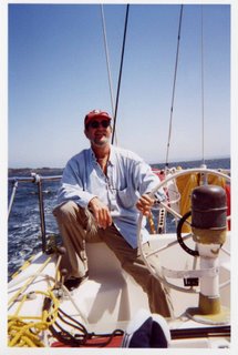
Captain Jim's Radio Telephone Tips
RANDOM NOTES ON RADIOTELEPHONE TIPS
By Captain James F. Barn CD
VTS (Vessel Traffic Services) is the arm of the CCG which aids the safety of shipping throughout
Let me assure you that it is not necessary to participate in the Service, we can listen but we may also utilize the channel for navigational/identification and other uses simply by keying the mike and using the proper procedure.
For instance if you observe a larger or commercial vessel with which you wish to exchange information this can be done simply and effectively.
Having been listening on the circuit, you may be aware (by previous VTS conversations) the vessel's callsign... .call the vessel .. .inform her who and where you are in relation to that vessel and .. .ask or exchange your information. OR
If you do not know who the vessel is... .call the VTS and inform of your position (geographical) and where the mystery vessel is situated in relation to your position.. ..VTS will identify that target for you and you may then communicate directly.
COMOX TRAFFIC CH#71 will assist you all the way to
TOFINO TRAFFIC CH#74 will assist you all the way to Juan de Fuca
Please leam how to use Distress, Urgency and Safety Signals and do not be timid on the use of your VHF Radio.
Consider buying a copy of Radio Aids to Marine Navigation plus a copy of List of Lights Buoys and Fog Signals (Pacific Coast) keeping this one corrected is simple and will let you get much longer use from those dog-eared charts we all keep under the for'd berth.
Channel 16 is, as we all know, a distress/calling frequency, commercial vessels for the large part only listen to this frequency but guard the Traffic frequency, I firmly believe if you start making it a habit of utilizing Traffic Services it will make all your outings more pleasant, professional and safe.
Hope these small tips help.
Jim
S/V WHIMSY II
Captain JFBnin CD
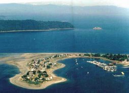
DEEP BAY
Captain Jim's Weather Tips
RANDOM NOTES ON WEATHER
By Captain James F. Barn CD
The old saying, stand with your back to the wind and the high pressure will be on your right side and the low pressure on the left, this and many other old mariners ditties are as true today as they were when there were iron crew and wooden ships. Might do us all good to review some of the old sayings regarding weather.
Watch your barometer, (or communicate with a cruising buddy who has one aboard) and as Ken showed you how.. ..do your own weather after listening to the b'casts. Be more than vigilant when nearing Brooks Peninsula where a phenomena termed 'Status Surge' can cause gale force winds suddenly and will come from the south, the fishermen call it 'fog wind' Forerunners are a rapid air temp drop accompanied by a drifting fog bank from the south. So.. ...since there is little radio warning on this nasty piece of work ..don't let your guard down, snug down and get out the cards.
Hope this helps
Jim
Suggested reading
Environment
Marine Weather Hazards Manual
Monday, May 21, 2007

Schedules
It eas decided at the meeting (20th) that most of us would depart as a group from the bay on Thursday 7th June @ noon, and overnight in Henry Bay.
We failed to set a date for the next meeting. Most of us will be attending the Opening Day next Saturday at 5:00 pm. so how about scheduling our next meeting for the Sunday before we depart, June 3rd, - same time same place.
Communications - Call on 16 - Use 9 as the chat channel.
Would everyone who has an MMSI# for their radio please forward to me so that I can post the list here.
Anyone planning to dress their boat for opening day?
Sunday, May 20, 2007
Over The Top

Picture from Google Earth looking over the Nawitti Bar towards Cape Scott in the background.
If you have Google Earth on your computer it is an excellent way to get a preview of your voyage by scrolling around on the different legs. You can even get a profile view like the one above by changing the perspective - the top bar on the on the Google Earth control panel on the top right of the screen. You can save the image from the "File" menu. Let's see who will be the first to send me an image of the view going into Winter Harbour.
Google Earth can be obtained as a FREE download from:
http://earth.google.com/
Barkley Sound to Victoria - Chart 3606
Olga McClean thoroughly researched the area and present the following information:-
Once called the “Graveyard of the Pacific” and now a “downhill run” the stretch of coast between Barkley Sound through the Juan de Fuca Straits has been the scene of numerous shipwrecks. At the turn of the century there were no lights on this lonely stretch of coast to aid navigation and many ships foundered on the rocky, windblown shore. An adventure to read is “The Valencia Story “by Michael C. Nitzel which chronicles the tragic demise of this passenger ship which sailed between
The
From Barkley Sound in the north it is 92 nautical miles to
Attention should be paid to the currents through Juan de Fuca
Refer to the Current Tables #5 Page 61 /62 as the current can vary from 2 .4 knots ebb to 1.5 flood
.
Fuel is available at the following places:
-Bamfield
-Port Renfrew
-
-
-Sehiu
-
1. On leaving Barkley Sound the first point reached is
The Swiftsure Shoal looms next and after this is negotiated the swells gradually decrease
2. The Juan de Fuca Strait is entered by crossing a line drawn between Carmanagh Point and
3. Pachena Point has a lighthouse and is the resting place of the ill fated ship Valencia and some of the wreckage can still be seen a low tide
4.
5.
6. Carmanagh Point starts the
7. Bonilla Point is a kayakers’ paradise and it has a light which is privately operated for the fishing fleet
In summer the bays in Port San Juan can provide shelter from the summer winds.
Various bays within Port San Juan can be accessed for anchorage
a) - Thrasher Cove has moderate shelter in prevailing northwest conditions
b) -
c) - Snuggery Cove and Port Renfrew in stable weather - room for unlimited boats. There are also limited supplies available and fuel can be carried by jerry can from the local garage
d) Woods Nose and Mill Cove .Each have room for one or 2 boats and offers protection from southeasterlies.
There is now no shelter until
NB. If landing in
a) a valid passport
OR
b) birth certificate AND photo identification
9.
This is not a customs port of entry. General store is well stocked
Makah Cutlural Centre is well worth a visit. It is a time capsule of coastal Indian life.
10.
11. Sooke Inlet. For most people this is the stopping point before the final stretch into
Crabbing is excellent around the spit. There are many sheltered anchorages within the basin. However, there can be lots of traffic as this harbour is used extensively by both commercial and pleasure craft.
-
- In
12.
13. Make your way around Race Rocks and it is advisable to favour the
14.
Located east of a line joining Colville Island and Shoal Point up to the Johnson Street Bridge is known as the Inner Harbour. The harbour is also an aerodrome and float planes arrive and take off on a regular basis. Check taxiing area before navigating harbour. This is a busy area with ferries, cruise ships, tugs with log booms and all manner of small craft.
a) Fisherman’s Wharf- usually busy but rafting a possibility
b)
c) Wharf Street has good facilities
d) Located in
Book which I found very useful:
1. Docks and Destinations
Peter Vassilopoulos
2. Waggoner Cruising Guide 2007
Wetherley Press
3.
A Dreamspeaker Cruising Guide Volume 1
Anne& Laurence Yeadon- Jones
4. Exploring
Doug Douglass & Reanne Hemingway-Douglass
………..and of course the bottomless pit of information on the internet

Friday, May 18, 2007
M/V Shagpoke - 40' Nordhaven

Three years of development by Pacific Asian Enterprise (P.A.E.) produced the smallest of the Nordhaven fleet of ocean-crossing motor vessels. Her size does not limit her non-stop cruising range thanks to her fuel capacity and full displacement hull design. She is designed to punch through heavy head seas, her high bow provides buoyancy and contributes to her dry ride while her long keel with a large protected rudder keeps her going where she is pointed and her passive stabilizers minimize the side rolls caused by beam seas. As a result of this technology, this type of vessel was the smallest production trawler to circumnavigate the world in 2000 in 26 weeks. Then in 2004 this vessel type joined the Nordhaven fleet again in crossing the Atlantic.
In September of 2004 I became the proud owner of Shagpoke. My partner, Bob Norman, brought the vessel from its home in Dana Point, CA to its new home in Deep Bay. In Bob's memory - I am carrying on with our plans of circumnavigating Vancouver Island. Captain James Bain (accompanied by his wife Toni) has graciously agreed to be my skipper for the journey. The journey will be a major accomplishment in many ways. I will be able to continue to learn the operation of the vessel and it will bring a community of people together to enjoy the many of the sites in our beautiful coastal waters of British Columbia. Bob's memory will also be honored as he was part of the initial idea to make this journey as a group.
It is my hope that we will all carry his memory in our hearts as we travel.
Tuesday, May 8, 2007
Staffed Lighthouses

All these lighthouses monitor channel 82a and 16. They indicate that they would be very happy to answer any inquiries you may have regarding weather, sea conditions etc. E.g. on the morning before rounding Cape Scott. The Coast Guard were contacted and indicate that if we have problem contacting the lighthouse they, the Coast Guard, can be contacted on 83a ( The new Coast Guard working channel) and that they would relay a message by land line.
Kyuquot Sound
Tara & Tim Coulter have thoroughly researched the area and present the following information:-
Kyuquot Sound
From
Kyuquot Sound is one of the five main sounds on the western coast of
Solander Island Ecological Reserve at the northern tip of Brooks Peninsula cannot be visited except with a permit. It provides refuge for many different species of birds including the Tufted puffin and of course, sea lions. Ecological reserves in BC were created to protect unique ecosystems with rare and endangered plant and animal species. In storm conditions, “winds off
Brooks Peninsula Provincial Park offers a wilderness experience for hardy adventurers who want to go ashore.
Boaters and kayakers are more familiar with Brooks Peninsula’s notorious intense weather. “The passage around Brooks Peninsula under storm conditions is one of the most hazardous on the West coast” (Marine Weather Hazards Manual, p. 97). However, calm waters do prevail; it’s just a matter of listening to the weather reports and choosing your day.
Columbia Cove at the entrance to Nasparti Inlet offers protected anchorage. There is a park trail that crosses the peninsula that gives you access to an exposed beach, perfect for beachcombing.
The Checleset Bay Ecological Reserve is home to sea otters. The indigenous sea otter population was hunted for pelts and was nearly wiped out in the early 1900s. In an effort to save the population from extinction, sea otters from
When the otters were in decline, crabs, sea urchins and abalone were plentiful as the main predator was missing from the food chain. The increase in the otter population has put pressure on shellfish in the area and some experts fear that some illegal culling is happening in the area in order to increase shellfish returns.
The
The Bunsbys were named by Captain Richards in 1863 after a Charles Dickens novel, “Dombey & Son”. Watmough says that “inside Gay Passage are some of the area’s best all-weather anchorages.” (Cruising Guide to the West Coast of Vancouver Island, p.63)
- Eastern side of
- West side of Gay Passage is secure but more open to SE winds.
- Between the southern most
Big Bunsby Provincial Marine Park encompasses the easternmost island in the group between Quoukinish Inlet and Malksope Inlet. This park was created to take pressure off Checleset Bay Ecological Reserve, a popular destination for ocean kayakers and other wilderness travelers hoping to catch a glimpse of a sea otter.
Elder, Lucy Paivio lives on
Elsie Hulsizer’s beautiful book, “Voyages to Windward – Sailing Adventures on
Names such as, Battle Bay, Skirmish Islets and Burial Island all point o the violent history of this area.
Carrying on from the Bunsbys to Walter’s Cove (and the First Nations community of Houpsitas) you will pass the now notorious poster child of clearcut logging,
Kayakers are warned of strong winds which can develop quickly during the passage from the Bunsbys to Walter’s Cove. Morning inflow winds and afternoon outflow winds are common in all the major inlets along the coast and should be taken into consideration especially if they are flowing in opposition to ingoing or outgoing tide.
Sea otters raft together in social displays of grooming their dense fur and can often be found near Chief Rock, just north of Walter’s Cove.
Both the Douglass and Don Watmough cruising guides highly recommend using large scale Chart #3651 to navigate the challenging entrance to Walter’s Cove (note this chart was missed on the initial chart recommendations).
Walter’s Cove is home to approximately 300 residents plus a resident seal, name ‘Miss Charlie”. Miss Charlie was rescued from her dying mother by c-section and raised in a bathtub by the Kayra family of Walter’s Cove. “…She celebrated her 34th birthday in 1998” (Douglass, p.108).
Half of the residents live in the First Nations community of Houpsitas while the remaining residents live across the bay in Walter’s Cove. Although there are two docks at Houpsitas, they are reserved for the First Nations community.
Walter’s Cove is the first community where provisioning is possible, but remember that this community is only reached by boat, so supplies may be limited depending on when the supply boat last restocked the general store (Thursdays).
Water is available (by donation) just south of the public wharf (340’) and a barge is also located in the Cove offering accommodations and showers (During a call in May/2007 to the General Store, I was told that no one was currently operating the showers and sometimes they are open and sometimes not.)
There is a garbage dumpster available, but be considerate as the garbage is removed weekly by boat. A small hospital, marine hardware store, pay phone, B & B, 6-unit motel and restaurant are also located in the friendly community of Walter’s Cove. Just remember to respect that this is a dry community – so no alcohol consumption please unless you are discreet and below decks.
Fuel is available a further 12 miles up the Sound at
Weekly service on the MV Uchuck III, a former World War II minesweeper is also available from
Note: No anchoring is allowed in Walter’s Cove due to the presence of marine cable and water lines (Douglass, p. 109).
Rugged Point Provincial Park is a remote park south of Kyuquot offering some challenging hiking and a beautiful beach. In Elsie Hulsizer’s book there is a photo with the following caption, “a hiking trail leads across the peninsula to one of the most beautiful sandy beaches on the coast.”
Rugged Point is located on the eastern shore of Kyuquot Channel. During a nor’wester one evening the Hulsizers took refuge in a small, nameless cove in nearby Amai Inlet that the Douglass refer to as ‘Petroglyph Cove’. The locals call it ‘Blue Lips Cove’ because it was so cold there, that their lips turned blue!
Dixie Cove Marine Park offers good all weather anchorage in Kyuquot Sound for a limited number of boats.
Cachalot is home to a unique Ferro cement sculpture of a sperm whale in honour of the some 4700 whales that were killed and processed by the Pacific Whaling Company at this location. A trip ashore will reveal a few bits and pieces of rusted machinery, but otherwise there is little trace of this once vibrant whaling station that employed 200 people at its peak of operations.
For those who like to explore, the coast between Kyuquot and
Contacts:
Kyuquot Band office
(Tel) 250-332-5259
Walter’s Cove General Store/Government Dock
250-332-5211
Voyageur Water Taxi
250-332-5301
Walter’s Cove Lodge
1-800-810-8933
(fly-in resort; no facilities for non-guests)
Resources:
Environment
Fisheries and Oceans
Harbord, Heather. Sea Kayak Nootka & Kyuquot Sounds.Rocky, Mountain Books:
Hulsizer, Elsie. Voyages to Windward – Sailing Adventures on
Watmough, Don. Cruising Guide to the West Coast of
Good article on sea otters in
www.canadiangeographic.ca/travel/adventure/guides/summer_2006/feature_otter.asp
Information on BC marine parks and safety tips:
Sunday, May 6, 2007
Weather Stations Chart

This is the chart you can use to record the weather data from the Coast Guard Radio broadcast. Print out a copy for your own use by clicking on the picture, to select it, and then click "Print" from the "File" menu on your browser.
Float Plan
Float Plan
Vessel name:
Vessel licence number or registration:
Captain's Name:
Address:
Telephone:
Vessel type (sail/power):
Model and size:
Color
Type of Engine(s):
Other distinguishing features:
Radios, channels monitored (HF/VHF/CB):
Life rafts (type, size, color):
Dinghy (type, size, color):
Other safety equipment:
Flares (number):
Lifejackets (number):
Other:
Trip Data
Leaving from:
Date: Time:
Destination:
Estimated Date: Time:
Proposed route:
Names of people on board:
Returning on date:
Route, date, time of arrival:
Call Search and Rescue at Date/Time:
Coast Guard #s - (250) 363-2994 (250) 363-2988 (250) 363-2992 1-800-567-5111
Comox Coast Guard Radio – (250) 339-3613
Sail Plans or Float Plans
Leave your float plan with a responsible friend and establish a reporting schedule. Each boat will be responsible for their own float plans.
If for any reason (i.e. no cell coverage north of
Ken will have copies of float plans available for the next meeting (May 20th - 12:30pm)
If you would like to print out your own float plan simply select and copy all the text from the next post and paste it into a word processing document (Word). This can then be saved, edited and printed out.
Do not use 22 as either a Coast Guard channel or chat channel. The Coast Guard does not monitor it any more but still have the rights on it as a backup channel..
Weather Channels:-
1 Comox
21b Chatham Point
3 Port Hardy
21b Holberg, Esperanza, Mt.
1 Eliza Dome, Nootka
2
3 Estevan Point, Juan DeFuca, Mt.Helmchen
21b Gulf Islands
3
Thursday, May 3, 2007


Rob Scott's Reefing Seminar
Find Rob's reefing diagrams below. (He suggests that you should be able to reef in 30 seconds or less) To see a larger view simply click on the diagram.
I thing that now may be an appropriate time to extend a big THANK YOU to Rob for his great effort in extending his enthusiasm, leadership, experience and guidance to all of those participating in this great adventure.
For a larger view of any diagram / picture simply click on it.
To print just click once on the diagram to select it and click the print icon at the top of your browser.

Monday, April 9, 2007
West Coast Odyssey of Cyndyn (8 Weeks)
Lyle and Judie Roberts were kind enough to attend our last meeting and share their experiences circumnavigating the Island on board their M/V Cyndyn. They have also provided a copy of their log which I have included below.
WEST COAST ODYSSEY OF CYNDYN
June 1, 2004: Left Nanaimo at 0800, arrived at Comox at 1530 53 miles
Margaret and Bruce, our friends on our companion boat, hit a submerged deadhead in Baynes Sound and required divers to check it out.
June 3: Left Comox at 0750, arrived Discovery Harbour Marina at 1225 33 miles
June 4: Left
June 5:
June 6:
June 7: Stayed in
June 8:
June 9: Remained at Port Hardy to help Margaret and Bruce return home.
June 10:
All boats were still waiting for weather to clear. 24 miles
June 11: Off to the Cape:
June 12: Remained at Sea Otter Cove, tied to mooring buoy. Winds gusting to 48 at
June 13: remained at Sea Otter Cove. More of the same – but saw huge orca. Other boats left, but sea state was 2-3 meters, so we stayed put
June 14:
June 16:
June 17:
June 18:
June 19: Left Julian Cove at 0900, “outside” to
June 20: Brooks Peninsula Day/Fathers’ Day. Left Klashkish Inlet at 0740, in full sun, reached
June 21: Left Columbia Cove at 1300 hours, after fog lifted, arrived at
June 22:
June 23: Left Walters Cove at 0900, sneaked through a short-cut rocky entrance into Kyoquot
Inlet to
June 24: Stayed at Inner Dixie Cove for a spa day for first mate. Captain caught a nice ling cod and a prawn trap full of hag fish. Ugh. No radio reception.
June 25: Left Inner Dixie Cove, Kyoquot Sound at 0900, explored Nuchalitz, home of the Nootka tribe, anchored in Queen Cove, Esperanza Inlet at 1345 29 miles
June 26: Remained in Queen Cove as crabbing was promising.
June 27: Left Queen Cove at 0900, arrived Zeballos at 1120.
Not much room at dock 15 miles
June 28: Layover day in Zeballos
June 29: Left Zeballos at 0920, arrived Tahsis at 1145. Westview Marina is good place to stay 15 miles
June 30: Left Tahsis late after morning winds abated at 1310. Passed Critter Cove at 1600 and anchored in Hisnit Inlet at 1620 1620. 21 miles
July 1:
Reached 600 nautical miles
July 2:
July 3: Left Bligh Cove at 0845. Fished, with no luck for two hours, then anchored in Friendly Cove to explore site. No dock, lots of anchorage . Went to Santa Gertrudis(or Dawley’s) Cove to anchor at 1330 6 miles
July 4: Left Santa Gertrudis at 0640 for trip around Estevan Point. Tough sledding for an hour or so. Arrived
July 5: Left Hot Springs Cove at 0830 to fish off Barney Islands, then motored up Sydney Inlet to Coyote (Bottleneck) Cove at 1125 8 miles
Good “back door” to Ahousat, Tofino, et al. Watch for crab traps all over the place.
July 6: Left Coyote Cove at 0820, added water and provisions at Ahousat, a good spot with a nice little restaurant. Lots of dock. Anchored at Friendly Dolphin Cove, near head of Clayoquot Sound, but on the quiet side of
July 7: Left Friendly Dolphin at 0845, investigated
Depending on sea conditions and weather reports, this might be one of many small anchorages to choose, rather than going into Tofino. That city’s marina is crammed full of derelict boats, with very little moorage for visitors, other than rafting to fish boats. They charge for water, too. Better to fill up at Ahousat, and again at Ucluelet. In an emergency, there is sometimes dock space at Weigh West, but they charge more than the city docks and are further away from town (although we walked it just fine).
July 8: Left West Whitepine Cove at 0855, arrived at Tofino at 1055. Tied up at Weigh West docks at 12:30 16 miles
July 9: Stayed in Tofino, for chores.
July 10: Left Weigh West dock at 0835. Motored out to fishing grounds (8 miles) and caught some lovely wild coho. Returned to Clayoquot and up to
July 11:
July 12:
July 13: So nice at Tranquilito Cove we stayed another day. Lyle swam.
July 14: Left Tranquilito Cove at 0845, made the run to Ucluelet and arrived at 1515. Nice peaceful passage, great harbourmaster. 38 miles
July 15/16: Stayed at Ucluelet
July 17: Left Ucluelet at 0800, but got held up at gas dock until 1030. Spent the night at
July 18-22: Exploration of Barkley Sound. Did not travel more than 10 miles per day, found exceptional anchorages. Did not like
July 23: Departed Eagles Nook at 0805, arrived at Bamfield at 1030. Got water, tied to Government dock on east side of bay (no water there). Fellow boaters convinced us to try Dodger Channel, right at the entrance to Barclay Sound (south west corner) just across from the entrance to Bamfield. If weather is calm, this is a beautiful way to say goodbye to the west coast. Sunset like a Vickers painting. 15 miles
July 24/25: Left Dodger Channel and returned to Bamfield, for protection against predicted NW gales. Tied to Government dock on west side of harbour. Stayed one extra day to let NW gales settle, walked to Brady’s Beach. Nice place.
July 26: Left Bamfield at 0610 to make passage to Port San Juan. Seas were high for the first hour, but subsided, giving us a nice ride. Sighted
July 27:
July 28: Moved around to
Total mileage for trip from
(Add mileage for trip from
We left
Although we traveled inland on many occasions, we did not go more than a day’s easy voyage off our track at any given time. We found places that we never would have discovered by car, and pretty much had them all to ourselves. So many boats rush down the west coast in order to complete the circumnavigation in a set number of days. Our voyage would have been shorter if we had passed up the side-trips, but except for the five days spent checking for hull damage and visiting medical help, we took seven weeks. We did not go to
The only two rough spots we had to be brave about were rounding Estevan Point and leaving Barclay Sound around
Water and fresh groceries will be your biggest challenges after leaving Port McNeill or Port Hardy. Best place, if you don’t go inland to Port Alice, Zeballos or Tahsis, is Ucluelet. At Tofino, as mentioned, it is difficult to find moorage. There is limited provisioning at
Enjoy every minute of your trip!
Lyle and Judie Roberts
cyndyn@shaw.ca
Subscribe to:
Posts (Atom)