Wednesday, May 30, 2007
S/V Ravens' Dream

Ravens' Dream is a 1976 - 30' Grampian sailing sloop. She is our
second sailboat since moving to British Columbia in 1988. We came
across her one evening in Nanaimo. We were out for a walk along
Stewart Avenue, on our way back to Port Hardy, when we both noticed a
mast with a great "rake" to it. It was love at first sight! We
decided to stay over night, and go back for a better look in the
morning. After a short sail around Newcastle Island, we negotiated a
deal, and now where the owners of two sailboats!
Our sailing lives have varied greatly. Mine had consisted of going
out occasionally as a guest on friends boats on Lake Ontario once in
awhile before moving to B.C., so with that and my mere 18 years of
sailing here, pails in comparison to Jim, who on the other hand has
been sailing since he was 6 years old. He was raised in Foster Care
and ended up with a family who had a son of their own who was
10 years older then Jim. Burt had taught himself how to sail by
rigging canoes with sails in the beginning, then he started building small sailboats himself.
By the time Jim was 6, Burt would take Jim with him and they
would sail around the Islands in Toronto harbour, Then by the time
Jim was 10 to 12 they began sailing across Lake Ontario usually at
night on Fridays. Burt taught Jim how to steer a compass course, and
he would go below and cook supper while Jim sailed the boat. Burt was
working by this time, so they would leave Friday evenings, over to
Niagara-on-the-Lake, and come back on Sunday afternoons. Even years
later when Jim had joined the Navy, and would come home to Toronto on
leave in the summer, they would still sail together.
We lived and worked in Port Hardy at the time we purchased Raven'
Dream (this is the name we gave her when we re-registered her) so we
sailed Queen Charlotte Strait, and then we moved to Comox in 1992 and
to Qualicum Bay in 2002 so we have enjoyed the Georgia Strait area,
Desolation Sound and the Sunshine Coast since. We where so pleased to
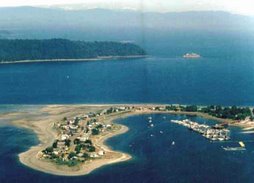
get moorage at the Deep Bay Marina, a secure snug harbour, with a
wonderful group of "sailors" for neighbours.
Both Jim and I are looking forward to favourable weather, and a great
sail on our "Around Together" adventure!
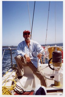
Skipper: Linda Thompson
First Mate: Jim Roberts
Barkley Sound - Chart 3671
Submitted by Niels W. Bang
As I have not sailed here, all my knowledge stems from the book “Exploring Vancouver Island’s West Coast”.
As you enter Barkley Sound, Ucluelet is known as a “safe landing place”.
Getting in to Ucluelet use caution, and if the weather is rough it is recommended to avoid Caroline Channel and use Feline Channel.
In Ucluelet there are generally 3 choices: Two public docks, or pick up a buoy on either side of
Ucluelet is a full service town. Petro
If you decide to stay a couple of days there is a great “Wild Pacific Trail”, starting at the lighthouse at Amphitrite Pt. (Brochure will go on the blog).
To explore Barkley Sound I would strongly recommend to follow the book as it seems to give an incredibly accurate description of anchor places and what to see.
The Broken Group and
The only waterway we have been on is the Alberni Inlet up to Bamfield – we took a day trip on “Lady Rose” from
In Robbers Passage between Tzartus and
Bamfield has all services available. The dock is for store use only - not for overnighters. There are mooring buoys north of Burlo, but they are busy in the summer months. Anchoring between the buoys can be done.
Grappler inlet 0.25 miles east of Bamfield has a lot slower pace than the Bamfield Inlet. There are numerous small bays in Trevor Channel to be explored.
Dodger Channel is one of the best sites for anchoring, viewing, and experiencing the exposed coast of Barkley Sound before heading towards
The channel is well sheltered in fair summer weather, but not a place to be caught in in foul weather.
Saturday, May 26, 2007
Captain Jim's Radio Telephone Tips
RANDOM NOTES ON RADIOTELEPHONE TIPS
By Captain James F. Barn CD
VTS (Vessel Traffic Services) is the arm of the CCG which aids the safety of shipping throughout
Let me assure you that it is not necessary to participate in the Service, we can listen but we may also utilize the channel for navigational/identification and other uses simply by keying the mike and using the proper procedure.
For instance if you observe a larger or commercial vessel with which you wish to exchange information this can be done simply and effectively.
Having been listening on the circuit, you may be aware (by previous VTS conversations) the vessel's callsign... .call the vessel .. .inform her who and where you are in relation to that vessel and .. .ask or exchange your information. OR
If you do not know who the vessel is... .call the VTS and inform of your position (geographical) and where the mystery vessel is situated in relation to your position.. ..VTS will identify that target for you and you may then communicate directly.
COMOX TRAFFIC CH#71 will assist you all the way to
TOFINO TRAFFIC CH#74 will assist you all the way to Juan de Fuca
Please leam how to use Distress, Urgency and Safety Signals and do not be timid on the use of your VHF Radio.
Consider buying a copy of Radio Aids to Marine Navigation plus a copy of List of Lights Buoys and Fog Signals (Pacific Coast) keeping this one corrected is simple and will let you get much longer use from those dog-eared charts we all keep under the for'd berth.
Channel 16 is, as we all know, a distress/calling frequency, commercial vessels for the large part only listen to this frequency but guard the Traffic frequency, I firmly believe if you start making it a habit of utilizing Traffic Services it will make all your outings more pleasant, professional and safe.
Hope these small tips help.
Jim
S/V WHIMSY II
Captain JFBnin CD
DEEP BAY
Captain Jim's Weather Tips
RANDOM NOTES ON WEATHER
By Captain James F. Barn CD
The old saying, stand with your back to the wind and the high pressure will be on your right side and the low pressure on the left, this and many other old mariners ditties are as true today as they were when there were iron crew and wooden ships. Might do us all good to review some of the old sayings regarding weather.
Watch your barometer, (or communicate with a cruising buddy who has one aboard) and as Ken showed you how.. ..do your own weather after listening to the b'casts. Be more than vigilant when nearing Brooks Peninsula where a phenomena termed 'Status Surge' can cause gale force winds suddenly and will come from the south, the fishermen call it 'fog wind' Forerunners are a rapid air temp drop accompanied by a drifting fog bank from the south. So.. ...since there is little radio warning on this nasty piece of work ..don't let your guard down, snug down and get out the cards.
Hope this helps
Jim
Suggested reading
Environment
Marine Weather Hazards Manual
Monday, May 21, 2007

Schedules
It eas decided at the meeting (20th) that most of us would depart as a group from the bay on Thursday 7th June @ noon, and overnight in Henry Bay.
We failed to set a date for the next meeting. Most of us will be attending the Opening Day next Saturday at 5:00 pm. so how about scheduling our next meeting for the Sunday before we depart, June 3rd, - same time same place.
Communications - Call on 16 - Use 9 as the chat channel.
Would everyone who has an MMSI# for their radio please forward to me so that I can post the list here.
Anyone planning to dress their boat for opening day?
Subscribe to:
Posts (Atom)