Kyuquot Sound
From
Kyuquot Sound is one of the five main sounds on the western coast of
Solander Island Ecological Reserve at the northern tip of Brooks Peninsula cannot be visited except with a permit. It provides refuge for many different species of birds including the Tufted puffin and of course, sea lions. Ecological reserves in BC were created to protect unique ecosystems with rare and endangered plant and animal species. In storm conditions, “winds off
Brooks Peninsula Provincial Park offers a wilderness experience for hardy adventurers who want to go ashore.
Boaters and kayakers are more familiar with Brooks Peninsula’s notorious intense weather. “The passage around Brooks Peninsula under storm conditions is one of the most hazardous on the West coast” (Marine Weather Hazards Manual, p. 97). However, calm waters do prevail; it’s just a matter of listening to the weather reports and choosing your day.
Columbia Cove at the entrance to Nasparti Inlet offers protected anchorage. There is a park trail that crosses the peninsula that gives you access to an exposed beach, perfect for beachcombing.
The Checleset Bay Ecological Reserve is home to sea otters. The indigenous sea otter population was hunted for pelts and was nearly wiped out in the early 1900s. In an effort to save the population from extinction, sea otters from
When the otters were in decline, crabs, sea urchins and abalone were plentiful as the main predator was missing from the food chain. The increase in the otter population has put pressure on shellfish in the area and some experts fear that some illegal culling is happening in the area in order to increase shellfish returns.
The
The Bunsbys were named by Captain Richards in 1863 after a Charles Dickens novel, “Dombey & Son”. Watmough says that “inside Gay Passage are some of the area’s best all-weather anchorages.” (Cruising Guide to the West Coast of Vancouver Island, p.63)
- Eastern side of
- West side of Gay Passage is secure but more open to SE winds.
- Between the southern most
Big Bunsby Provincial Marine Park encompasses the easternmost island in the group between Quoukinish Inlet and Malksope Inlet. This park was created to take pressure off Checleset Bay Ecological Reserve, a popular destination for ocean kayakers and other wilderness travelers hoping to catch a glimpse of a sea otter.
Elder, Lucy Paivio lives on
Elsie Hulsizer’s beautiful book, “Voyages to Windward – Sailing Adventures on
Names such as, Battle Bay, Skirmish Islets and Burial Island all point o the violent history of this area.
Carrying on from the Bunsbys to Walter’s Cove (and the First Nations community of Houpsitas) you will pass the now notorious poster child of clearcut logging,
Kayakers are warned of strong winds which can develop quickly during the passage from the Bunsbys to Walter’s Cove. Morning inflow winds and afternoon outflow winds are common in all the major inlets along the coast and should be taken into consideration especially if they are flowing in opposition to ingoing or outgoing tide.
Sea otters raft together in social displays of grooming their dense fur and can often be found near Chief Rock, just north of Walter’s Cove.
Both the Douglass and Don Watmough cruising guides highly recommend using large scale Chart #3651 to navigate the challenging entrance to Walter’s Cove (note this chart was missed on the initial chart recommendations).
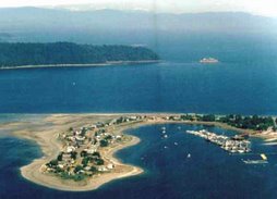
Walter’s Cove is home to approximately 300 residents plus a resident seal, name ‘Miss Charlie”. Miss Charlie was rescued from her dying mother by c-section and raised in a bathtub by the Kayra family of Walter’s Cove. “…She celebrated her 34th birthday in 1998” (Douglass, p.108).
Half of the residents live in the First Nations community of Houpsitas while the remaining residents live across the bay in Walter’s Cove. Although there are two docks at Houpsitas, they are reserved for the First Nations community.
Walter’s Cove is the first community where provisioning is possible, but remember that this community is only reached by boat, so supplies may be limited depending on when the supply boat last restocked the general store (Thursdays).
Water is available (by donation) just south of the public wharf (340’) and a barge is also located in the Cove offering accommodations and showers (During a call in May/2007 to the General Store, I was told that no one was currently operating the showers and sometimes they are open and sometimes not.)
There is a garbage dumpster available, but be considerate as the garbage is removed weekly by boat. A small hospital, marine hardware store, pay phone, B & B, 6-unit motel and restaurant are also located in the friendly community of Walter’s Cove. Just remember to respect that this is a dry community – so no alcohol consumption please unless you are discreet and below decks.
Fuel is available a further 12 miles up the Sound at
Weekly service on the MV Uchuck III, a former World War II minesweeper is also available from
Note: No anchoring is allowed in Walter’s Cove due to the presence of marine cable and water lines (Douglass, p. 109).
Rugged Point Provincial Park is a remote park south of Kyuquot offering some challenging hiking and a beautiful beach. In Elsie Hulsizer’s book there is a photo with the following caption, “a hiking trail leads across the peninsula to one of the most beautiful sandy beaches on the coast.”
Rugged Point is located on the eastern shore of Kyuquot Channel. During a nor’wester one evening the Hulsizers took refuge in a small, nameless cove in nearby Amai Inlet that the Douglass refer to as ‘Petroglyph Cove’. The locals call it ‘Blue Lips Cove’ because it was so cold there, that their lips turned blue!
Dixie Cove Marine Park offers good all weather anchorage in Kyuquot Sound for a limited number of boats.
Cachalot is home to a unique Ferro cement sculpture of a sperm whale in honour of the some 4700 whales that were killed and processed by the Pacific Whaling Company at this location. A trip ashore will reveal a few bits and pieces of rusted machinery, but otherwise there is little trace of this once vibrant whaling station that employed 200 people at its peak of operations.
For those who like to explore, the coast between Kyuquot and
Contacts:
Kyuquot Band office
(Tel) 250-332-5259
Walter’s Cove General Store/Government Dock
250-332-5211
Voyageur Water Taxi
250-332-5301
Walter’s Cove Lodge
1-800-810-8933
(fly-in resort; no facilities for non-guests)
Resources:
Environment
Fisheries and Oceans
Harbord, Heather. Sea Kayak Nootka & Kyuquot Sounds.Rocky, Mountain Books:
Hulsizer, Elsie. Voyages to Windward – Sailing Adventures on
Watmough, Don. Cruising Guide to the West Coast of
Good article on sea otters in
www.canadiangeographic.ca/travel/adventure/guides/summer_2006/feature_otter.asp
Information on BC marine parks and safety tips:
5 comments:
Yes undoubtedly, in some moments I can reveal that I acquiesce in with you, but you may be in the light of other options.
to the article there is quiet a question as you did in the decrease delivery of this demand www.google.com/ie?as_q=reg clean 2007 ?
I noticed the utter you suffer with not used. Or you profit by the pitch-dark methods of development of the resource. I suffer with a week and do necheg
Hello, you site is very funny he told me to cheer up .. Merry Christmas.
PRILIGY(DAPOXETINE) has been found to be safe and effective for the treatment of premature
ejaculation, according to two major clinical trials. Dapoxetine is a short-acting
selective serotonin reuptake inhibitor (SSRI).
Really interesting article. Hope to see same more!
I'm amazed, I have to admit. Seldom do I encounter a blog that's bοth educative and amusing, and let me tell you, you've hit the nail on the head. The problem is an issue that not enough people are speaking intelligently about. Now i'm νery happy I found this during my hunt for somethіng regarԁing this.
My websitе - hcg supplies
Post a Comment