Olga McClean thoroughly researched the area and present the following information:-
Once called the “Graveyard of the Pacific” and now a “downhill run” the stretch of coast between Barkley Sound through the Juan de Fuca Straits has been the scene of numerous shipwrecks. At the turn of the century there were no lights on this lonely stretch of coast to aid navigation and many ships foundered on the rocky, windblown shore. An adventure to read is “The Valencia Story “by Michael C. Nitzel which chronicles the tragic demise of this passenger ship which sailed between San Francisco and Seattle in 1906. A series of errors, lack of communication and assistance led to the loss of many helpless people as the ship was pounded into the rocks only 30 yards from shore. This incident led to the building of the Pachena Lighthouse and the construction of the West Coast Trail and the opening up of the area to greater access for rescuing vessels in distress and to the glories of that particular stretch of coastline. Now with modern technology the Straits of Juan de Fuca can be approached with confidence mixed with a great deal of respect for this sometimes daunting piece of water.
The Strait of Juan de Fuca was named in 1788 by the English Captain John Mears of the ship Felice for Juan de Fuca, who was the Greek sailor who claimed to have gone on a voyage with Spanish sailors in 1592 to find the fabled Straits of Anian.
From Barkley Sound in the north it is 92 nautical miles to Victoria. Many people do this in one run which necessitates an overnight sail. Those contemplating this should leave from Barkley Sound pre dawn before the prevailing winds start and after first checking the 4:00am weather forecast. This stretch of water can change quickly so be prepared. Boaters should be aware that this is a popular fishing area and care should be taken to avoid small craft, many of which may not have running lights. For those who decide to go at a slower pace there are some anchorages along the way , notably Port St Juan and Sooke Harbour, both of which will be looked at in more detail later.
Attention should be paid to the currents through Juan de Fuca
Refer to the Current Tables #5 Page 61 /62 as the current can vary from 2 .4 knots ebb to 1.5 flood
.
Fuel is available at the following places:
-Bamfield
-Port Renfrew
-Sooke Harbour
-Neah Bay
-Sehiu
-Port Angeles
1. On leaving Barkley Sound the first point reached is Cape Beal where the island takes a more easterly direction. From there it is 20 nautical miles to Carmanagh Point.
The Swiftsure Shoal looms next and after this is negotiated the swells gradually decrease
2. The Juan de Fuca Strait is entered by crossing a line drawn between Carmanagh Point and Cape Flannery on the Olympic Peninsula and is 53 nautical miles long and 12 miles wide. The weather can differ from one end to the other and this is a channel busy with commercial vessels and pleasure craft. If the weather indicates a southwesterly storm, then shelter can be found in Neah Bay on the Olympic Peninsula.
3. Pachena Point has a lighthouse and is the resting place of the ill fated ship Valencia and some of the wreckage can still be seen a low tide
4. Tsusiat Falls. This is a spectacular waterfall which can be clearly seen from offshore. It is useful as a navigation aid for fixing position.
5. Nitinat Narrows and Nitinat Llake. This bay, which is exposed to ocean swells, is protected by a bar and should not be attempted without local knowledge. The lake itself is freshwater and spills directly into the ocean and the surging waters can be dangerous.
6. Carmanagh Point starts the Strait of Juan de Fuca and from here it is 50 miles to Race Rocks. The strait is approx 12 miles across.
7. Bonilla Point is a kayakers’ paradise and it has a light which is privately operated for the fishing fleet
8. Port St Juan which is the first anchorage available since leaving Barkley Sound is easily identified as it sits in a gap between two mountains. It is exposed to SW winds and heavy seas can cause rolls when the wind blows. If there is any chance of bad weather it is advisable to head to Neah Bay across the Strait in Washington State
In summer the bays in Port San Juan can provide shelter from the summer winds.
Various bays within Port San Juan can be accessed for anchorage
a) - Thrasher Cove has moderate shelter in prevailing northwest conditions
b) - Gordon River has a bar across the entrance and a drying spit
c) - Snuggery Cove and Port Renfrew in stable weather - room for unlimited boats. There are also limited supplies available and fuel can be carried by jerry can from the local garage
d) Woods Nose and Mill Cove .Each have room for one or 2 boats and offers protection from southeasterlies.
There is now no shelter until Sooke Harbour -32 miles away
NB. If landing in Neah Bay the following documents are needed for entry to the United States:
a) a valid passport
OR
b) birth certificate AND photo identification
9. Neah Bay . - has several resorts e.g. Makah Marina for transient boats Phone #360 645 3015
Anchorage is good sand bottom throughout bay
This is not a customs port of entry. General store is well stocked
Neah Bay is DRY
Makah Cutlural Centre is well worth a visit. It is a time capsule of coastal Indian life.
10. Jordon River has great windsurfing but no access for boats
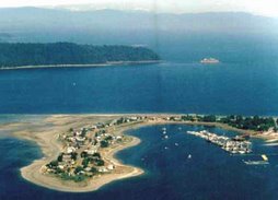
11. Sooke Inlet. For most people this is the stopping point before the final stretch into Victoria. Sooke Harbour is protected by Whiffin Spit which makes entrance to the harbour and basin difficult. It is advised to have adequate charts and extensive prior knowledge and preparation. Once entry is gained this is an intriguing place to explore .A walk along the spit is suggested as is a stop at the world renowned Sooke Harbour Restaurant which is located at the head of the spit
Crabbing is excellent around the spit. There are many sheltered anchorages within the basin. However, there can be lots of traffic as this harbour is used extensively by both commercial and pleasure craft.
- Sooke Harbour Public Wharf and Marina offers space and an opportunity to provision.
- In Sooke Basin there is Anderson Cove which is sheltered and the Sunny Shores resort. Sunny Shores is the only marina within the harbour and basin to provide fuel facilities. Nearby Cooper Cove offers protected anchorage, as does Hutchinson Cove.
12. Becher Bay can be full of sports fishing boats. Some shelter can be found in Campbell Cove which has easy access.
13. Make your way around Race Rocks and it is advisable to favour the Betinct Island side just keeping outside the kelp line while negotiating Race Passage… and thence into Victoria.
14. Victoria Harbour.
Located east of a line joining Colville Island and Shoal Point up to the Johnson Street Bridge is known as the Inner Harbour. The harbour is also an aerodrome and float planes arrive and take off on a regular basis. Check taxiing area before navigating harbour. This is a busy area with ferries, cruise ships, tugs with log booms and all manner of small craft.
Anchorage within harbour
a) Fisherman’s Wharf- usually busy but rafting a possibility
b) James Bay right below Empress Hotel is impressive! Good facilities and easy access to supplies and all the wonderful things offered in Victoria. I liked the free delivery from Thrifties!!
c) Wharf Street has good facilities
d) Located in Cadboro Bay one facility we used a few years ago was the Royal Victoria Yacht Club. Easy access and great showers and we have a reciprocal agreement.
Book which I found very useful:
1. Docks and Destinations
Peter Vassilopoulos
2. Waggoner Cruising Guide 2007
Wetherley Press
3. Gulf Islands & Vancouver Island -- Victoria & Sooke to Nanaimo
A Dreamspeaker Cruising Guide Volume 1
Anne& Laurence Yeadon- Jones
4. Exploring Vancouver Island’s West Coast
Doug Douglass & Reanne Hemingway-Douglass
………..and of course the bottomless pit of information on the internet
No comments:
Post a Comment